Beyond the reach of any ski lifts or souvenir stalls there is a shimmering wilderness in the heart of Switzerland, and through it runs a frozen river more than a mile wide.
For sheer spectacle, it ranks with the Matterhorn and Mont Blanc, yet comparatively few overseas tourists have heard of, let alone visited, the Aletsch, the Alps’ greatest glacier. Now, as many European cities endure record summer temperatures, a journey here offers the promise of blissful respite from the heatwaves — but also a poignant sense that, for the glacier, time is running out.
The ice is melting, and its surface is sinking as if some cosmic power had pulled the plug on a giant bath. An astonishing 4bn litres of water can run off it on a single hot summer’s day. Since official records began in 1892, its surface level has dropped at different points between 200 and 400 metres, and it has retreated by more than 3km in length. Recently, the pace of destruction has accelerated, and its snout is now shrinking at a rate of more than 50 metres a year. Under the most pessimistic scenario, the glacier, which contains a fifth of all the ice in Switzerland, could disappear entirely by 2100, leaving behind a desolate and rocky landscape, with the scant consolation of a series of lakes nestling along the valley floor.
For now, it is still so vast, about 23km long, covering an area of 79 sq km and with a maximum depth of 800 metres, that, however long it has left, it is likely to be among the last patches of ice to survive in the Alps. So, my midsummer trek along the length of the glacier is not strictly “last chance” tourism, yet, wherever I choose to look, there are ominous signs of a vanishing world.
My journey begins in Grindelwald, a popular holiday resort in both summer and winter, sitting below the looming north face of the Eiger. Heinrich Harrer, one of the four-strong team to make the epic first ascent of the face in 1938, named his book The White Spider, after an ice field near the summit. But when I gaze up towards it from the “Eiger Express” cable car, which wafts me in 15 minutes from the town at 947 metres to the Eigergletscher station at 2,320 metres, the face is a bare expanse of rock with only small smudges of snow.
I transfer to the rack and pinion railway which snakes up through tunnels blasted inside the Eiger and the Mönch, to the Jungfraujoch railway station, at 3,454 metres. Midway, we stop briefly at the Eismeer station, where a series of windows look out through the Eiger’s east side at the tumbling Ischmeer glacier.
The tunnel system was completed in 1912 — a remarkable feat of engineering for the time — but is now at risk from the melting permafrost. Railway engineers make regular checks, even stepping out from the tunnel through the Stollenloch doorway onto the north face itself, searching for fresh cracks in the rock.
The train continues, and 26 minutes after we entered the tunnel, we emerge into dazzling sunshine. It is shortly before 9am, and for now, the temperature is a reassuringly bracing -2C.
Adrian Kaelin, the guide who will lead our party of five for the two-day trip, carries a rope, ice axe and crampons. I spot him immediately among the milling crowds of tourists, mostly from China and elsewhere in Asia. The Jungfraujoch is the highest railway station in Europe, visited by more than one million day trippers a year. They come for a wonderland with guaranteed snow and ice and stay for the restaurants, boutiques, viewing platforms and ice palace. Outside, queues snake in the snow as visitors pose for photographs in front of the Swiss flag. Many are on a bucket list tour of Europe, and this is their only encounter with the Alps.
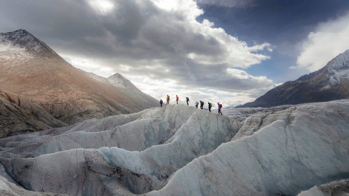
We put on our body harnesses, to protect us in case we fall into a crevasse, sling on our rucksacks and all five of us attach ourselves to Adrian’s rope. We walk through a tunnel and then slip past the Jungfraujoch boundary, heading for the open glacier. The tourists are behind us and, suddenly, we are alone in a pristine environment, a Unesco World Heritage Site.
Our target for the night is a four-hour march away, the Konkordia Hut, a refuge for climbers and trekkers and the only building along the course of the Aletsch. Walking in a roped group in soft snow is not remotely technical but can feel as undignified as playing the back end of a pantomime horse. The challenge is to maintain a set distance from the person in front, so that the rope neither drags nor pulls taut, but the snow can be as unstable as a sand dune. The sun beats down and soon, even amid a world of ice, we are perspiring in the fierce glare.
Eventually we pass from the featureless snow of the upper glacier to the boulder-strewn moraine which leads to the Konkordia Hut at 2,850 metres. But our journey is not quite over.
The original hut was built in 1877 on a rocky outcrop, perched just above the surface of the glacier. Now the ice has sunk so far that the hut has been left high and dry — a series of steel staircases, bolted to the cliff edge, are now needed to reach it.
When I last came here, almost 40 years ago, a school friend and I had just climbed the Finsteraarhorn, setting off at 3.30am and arriving at the Konkordia in darkness, exhausted after wading for hours through deep snow. Tramping up the staircases with heavy rucksacks felt like a cruel ordeal — yet in those days, it cannot have continued for much more than a couple of hundred steps.
Now visitors must clatter up 526 steps, 59 of them just added at the end of June to keep pace with the glacier’s accelerating decline.
We are the first visitors of the day to arrive and we celebrate with beers on the terrace. The vista stands comparison with the great mountainscapes of the world, from the Karakoram in Pakistan to the Andes in Patagonia. Immediately below us, the surface of the glacier is a geometric delight, forming endlessly intricate tessellations.
Again and again, the eye is drawn to the skyline, seeking out the seven 4,000-metre peaks that overlook the glacier, including the Mönch, the Jungfrau and the Aletschhorn. (The Eiger may be the most notorious, but at 3,970 metres falls just shy of the mark.) Then our gaze switches to the great curve of the glacier as it sweeps beyond us, down towards the Rhône valley, the dark stripes of the medial moraines giving it the appearance of a speedway.
The simple hut I remember has long since been rebuilt, but the rhythms of mountain life appear largely unchanged. A convivial, communal dinner of soup, pasta and a simple dessert is served at 6.30pm, and by 9pm, the 16 guests have almost all disappeared to the dormitories, with alarms set for 4.30am.
I chat with Andreas Mazenauer, 57, the hut warden who says dust regularly blows over from the Sahara, and that anything which reduces the reflectivity of the ice makes it disappear even faster. He flicks compulsively through webcam images, recorded continuously from the hut: “Look at the glacier in 2015 — the difference is enormous.” Even so, he adds: “the hut will stay in business for a long time. It’s just that the staircase will have to become ever longer.”
Next morning we are greeted by perfect crisp conditions. Instead of reversing down the stairs, we follow a hillside track for a couple of kilometres to rejoin the glacier “downstream”. On this lower section, the ice is bare, and crampons grip with a satisfying crunch. The surface of the glacier is alive with limpid streams, and we skirt carefully around crevasses which plunge into the depths. We navigate giant dunes of ice as we make landfall at the foot of the Eggishorn.
The adventure is almost over — but there is still time to head up to the Moosfluh, a ridgetop viewpoint from which to drink in the classic panorama of the Aletsch. Alpine roses and musk yarrow grow on the hillside and there is a heady aroma in the summer breeze.
At the end of the glacier I can see the destruction unleashed when it crumbles and the permafrost that binds together the surrounding landscape starts to melt. There have been landslides near the neck of the glacier and deep chasms have formed. The area is closely monitored for subsidence with satellite, radar and high-resolution cameras. Just 18km away lies the village of Blatten, which made headlines across the world when it was crushed in late May under a landslide of 9mn cubic metres of ice, rock and mud.
Rockfalls and instability have already forced the closure of some of Switzerland’s 60,000km of colour-coded hiking trails. The Swiss Alpine Club recently found that a third of its 152 mountain huts could be unstable because of thawing permafrost and that 29 huts close to glaciers will no longer be able to rely on them for water supplies by 2030. The cost of adapting the huts to climate change is expected to cost 100mn Swiss francs by 2040.
What can be done to halt the destruction? Matthias Huss, head of the official Swiss glacier mapping authority, Glamos, says that the top half of the Aletsch, including the basin in front of the Konkordia Hut, could still be saved if the world achieves net zero by 2060. But he has seen too many small glaciers disappear to be optimistic.
“It’s a hard-to-describe feeling for a glaciologist to witness this final point, to document it and to close the folder after decades of observation,” he said. “On the one hand, there is a feeling of fascination in being a direct witness. On the other hand, it’s like losing an old friend.” On the demise of Pizol glacier in 2023, he removed some of the last remaining ice. “I keep it safe in my freezer,” he said.
Even prayers have not been enough. From the Moosfluh, I walk back down to the village of Bettmeralp then, after a night at the Hotel Waldhaus, descend by cable car to the floor of the Rhône valley and a train to Geneva. An alternative route ends at the village of Fiesch, where, in 1678, villagers began praying that the great glacier above their homes would stop advancing, and thus menacing their farmland and livelihoods. Since 2012, though, they have made an annual summer procession to the mountainside chapel at Ernerwald to offer a prayer that, with papal approval, has been reversed. Now it calls for the preservation of the life-giving glacier that provides water and, through tourism, supports the community.
The sun rises, the ice melts into a trickle and is gone. When the clock chimes the appointed hour, will the magic end?
Find out about our latest stories first — follow FT Weekend on Instagram, Bluesky and X, and sign up to receive the FT Weekend newsletter every Saturday morning
Read the full article here