A short blast of polar air next week, combined with a storm expected to track into the eastern part of the country, could bring wet, windy, and snowy weather conditions.
Meteorologists at the Weather Channel laid out what to expect next week:
-
Monday – Monday Night: An initial wave of moisture along this frontal system’s warm front will wring out mostly nuisance rainfall in a bulk of the East as northern New England and northern New York see snowfall.
-
Tuesday – Tuesday Night: The Interstate 95 corridor should stay dry, but interior areas will see rain as a wave of low pressure on the cold front approaches.
-
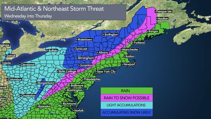
Wednesday – Wednesday Night: The heaviest rain from this setup will unfold ahead of the cold front during this time along the Northeast coast, and it could be accompanied gusty winds. Colder air arriving behind the system might change rain to a brief period of snow in interior areas as lake-effect snow develops in the Great Lakes snowbelts.
Weather Channel senior meteorologist Chris Dolce provided more details about the upcoming storm:
-
Much of the mid-Atlantic and Northeast could see at least an inch of rainfall from this setup. Parts of New York tri-state area and New England might see up to 3 inches. Snowfall will precede the heavy rain in northern New England, so that’s why the map below doesn’t show rain in those areas yet.
-
While some accumulating snow could impact interior areas of the Northeast as colder air arrives Wednesday and Wednesday night, the heaviest totals will be from lake-effect snow. Some Great Lakes snowbelts could pick up 6 to 12 inches of snow Wednesday through Thursday.
Dolce also provided a five-day rain and snow forecast for the eastern part of the country.
Separately, meteorologist Ryan Kane provided his forecast for next week’s storm:
The meteorologist for the Baltimore-Washington metro area, Tony Pann, at WBAL News, shows the possibility of a snow event for the interior Mid-Alantic (DC might be in for some of the white stuff ((sorry, Hunter Biden, not that white stuff)) and Northeast.
When I was a kid, we used to play hockey in the street. When a car was coming, someone would yell “Car!”. Then “Game on!” when it passed. Looking at the Euro forecast for Wednesday, you would yell “Car!”. 😁 And the GFS is “Game on!”. 👇 Will it snow? Maybe. Stay tuned…❄️🚂 pic.twitter.com/Wy27B9JoIL
— Tony Pann (@TonyPannWBAL) December 8, 2024
More from Kane:
The trends are towards a more amplified system Wed-Thurs. Better vort consolidation & notice the vorticity wrapping further west into the colder air. Watching trends today & then we watch mesoscale models tomorrow. Models catching onto the dynamics of neg. tilted trough. #MdWx pic.twitter.com/kFTlZXQ1Fo
— Ryan Kane (@ryankanerWX) December 8, 2024
A retired Weather Channel and NWS climate expert provided his forecast for next week.
Great Lakes turn on again mid-week for lake-effect #snow. Waaay too early to get into details, but westerly flow will set up strong bands east of Erie and Ontario. Stay tuned… @NWSBUFFALO @weatherchannel pic.twitter.com/G7yyf3pq8L
— Tom Niziol (@TomNiziol) December 8, 2024
Meteorologist Ben Noll noted, “In the US, a short but sharp polar blast looms later this week.”
In the U.S., a short-but-sharp polar blast looms later this week.
But watch as several rounds of milder, Pacific air follow during the week of December 16th.
Colder than average air may be at a premium during the second half of the month. pic.twitter.com/luQDOJwAMD
— Ben Noll (@BenNollWeather) December 8, 2024
Data from Bloomberg shows the latest cold spell will dissipate across the Lower 48 into warmer conditions through the first half of the week. However, temps are set to slide back into chilly conditions by the second half of the week.
Are you dreaming of a white Christmas?
But, not so fast…
Demand for firewood surges…
Searches For ‘Cords Of Wood’ Hit Record As Cold Blast Chills Lower 48 https://t.co/IANchzoma8
— zerohedge (@zerohedge) December 1, 2024
What happened to Greta’s global warming?
Loading…
Read the full article here

